

Latest Products
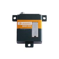

Aluminum Case Coreless Digital Servo DMC 811
$29.99
$39.99


HEQ Swan K1 Mapping VTOL Mapping Drone
The HEQ Drone Swan-K1 Mapping VTOL is a Small VTOL Mapping UAV for surveying and mapping fixed-wing UAV that can take off and land vertically, as well as switch flight modes with one button. Swan K1 Mapping drone adopts no rudder surface control technology, which brings users a minimalist control experience. The most important is it could get a centimeter-accurate Map without GCPs (ground control points), which truly achieves GCPs-free control measurement. Swan-K1 mapping has the advantages of being lightweight, portable, convenient for disassembly and installation, single-person operation, long battery life, etc. advantages. It can be used in surveying and mapping, measurement, remote inspection, power inspection, urban planning, energy projects, and road construction projects, mine surveying and other industries.
HEQ Swan K1 VTOL Mapping Drone Specifications
| Camera | |
| Size | 75×65×90 mm (including 25 mm lens) |
| Weight | 220g (including lens) |
| Pixel | 24.3 million pixels |
| Camera frame | APS frame |
| Sensor size | 23.5×15.6 mm |
| Maximum resolution | 24MP |
| Lens mount | Sony E mount |
| Access current | 2~7S 10~30V |
| PPK module | |
| Operating temperature | -30~+75℃ |
| GNSS signal | GPS、GLONASS、BDS、Galileo |
| GNSS channel | 72 |
| Update rate | 5Hz |
| Input voltage | 5V |
| Antenna voltage | 3.3V |
| Average current | 25mA |
| Data storage | 16 GB |
| Data Format | RINEX |
| Antenna interface | Mcx |
| Light | Trigger, satellite, storage, power |
| Horizontal accuracy | 2 cm+1ppm |
| Vertical accuracy | 4 cm+1ppm |
| Work efficiency | |
| Overlap rate | 80%×70% Resolution 5/10/20 cm 60 mins flight time |
| 1:500 Flying height 210 m | 2-3 square kilometers per flight |
| 1:1000 Flying height 420 m | 4-5 square kilometers per flight |
| 1:2000 Flying height 840 m | 8-9 square kilometers per flight |
| Operation accuracy | |
| 1:500 Without ground control points | Horizontal accuracy≤ 5 cm |
| Vertical accuracy≤ 5 cm | |
| 1:1000 Without ground control points | Horizontal accuracy≤ 8 cm |
| Vertical accuracy≤ 10 cm | |
| 1:2000 Without ground control points | Horizontal accuracy≤ 15 cm |
| Vertical accuracy≤ 20 cm |
RETURNS POLICY
1. Please contact us first with following information before shipping back:
-order number/contact person
-reason for returning
After confirmed with us, return instructions will be emailed to you.
2. We may require restocking fee(shipping cost) for returned merchandise without any quality problems. A re-stocking fee does not apply to defective products.

3. All merchandise returned must be packaged well to protect it from shipping damage, and must be sent with a shipping method that provides tracking information. We can not be held responsible for damage that occurs in transit.
4. For merchandise that a customer wants to return for a refund, We requires that the item and its packaging be in un-used, "like new" condition with all original packaging, cabling, manuals, etc. included, or the return will be refused. Inspect your product carefully before shipping as any signs of wear or use will result in a refused product return.
Please also include a note about your personal Info and the problems.
1.Your order number/Contact person
2.Your Detailed shipping address
3.why you have to return it?
4.what do you need us to do?
5.which part is broken?
6.Any problem you can find so far with the returned item.
SHIPPING
After order placed, you will receive a confirmation email.Once your order is shipped, you will receive tracking number and link via email.We offer express shipping , battery shipping, drone shipping to all over the world.If you have special declare value, shipping company requirment, please email us: hi@insightfpv.com